
» About » Archive » Search » Forum » RSS Feed Updates Wednesdays
No. 23: This strip's name is...not important.
First | Previous | 2015-07-01 | Next | Latest
First | Previous | 2015-07-01 | Next | Latest
Permanent URL: https://mezzacotta.net/pomh/?comic=23
Strip by: Ian Boreham
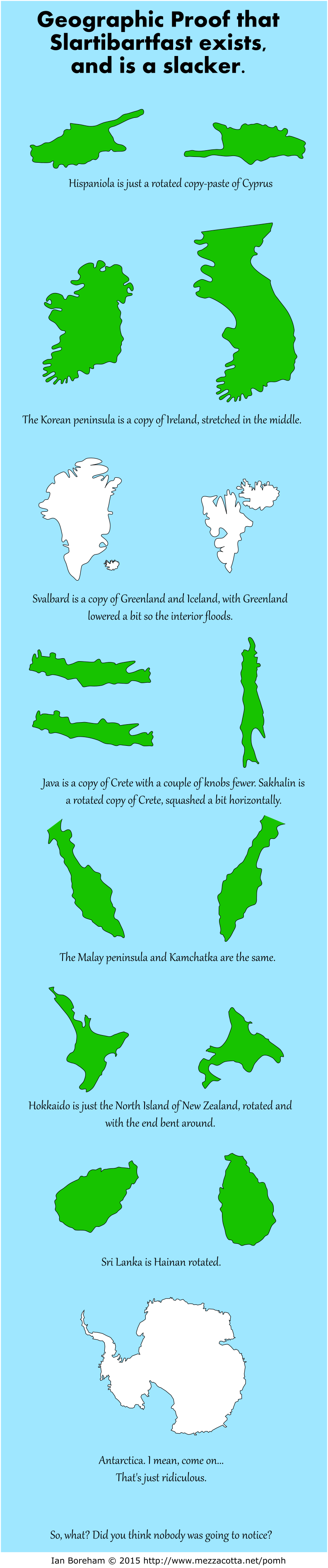
Heading: Geographic Proof that Slartibartfast exists, and is a slacker.
{Image of the islands of Cyprus and Hispaniola.}
caption: Hispaniola is just a rotated copy-paste of Cyprus.
{Image of Ireland and the Korean Peninsula.}
caption: The Korean peninsula is a copy of Ireland, stretched in the middle.
{Image of Greenland and Iceland, as well as the islands of Spitsbergen and Nordaustlandet in Svalbard.}
caption: Svalbard is a copy of Greenland and Iceland, with Greenland lowered a bit, so the interior floods.
{Image of Crete, Java and Sakhalin.}
caption: Java is a copy of Crete with a couple of knobs fewer. Sakhalin is a rotated copy of Crete, squashed a bit horizontally.
{Image of the Malay peninsula and Kamchatka.}
caption: The Malay peninsula and Kamchatka are the same.
{Image of the north island of New Zealand, and Hokkaido.}
caption: Hokkaido is just the North Island of New Zealand, rotated and with the end bent around.
{Image of Hainan and Sri Lanka.}
caption: Sri Lanka is Hainan rotated.
{Image of Antarctica.}
caption: Antarctica. I mean, come on... That's just ridiculous.
So, what? Did you think nobody was going to notice?
The author writes:
I told you it wasn't important.
Of course, the ultimate example of "intelligent design" of islands is World Islands, UAE
The world is full of land masses that look like they were designed by someone who was just making it up. Necklaces of islands like the Aleutians, the Kuriles, the Ryukyu archipelago and Frisia. Enormous land masses like Eurasia-Africa in one place, and crazy numbers of islands scattered all over Indonesia and the Philippines, and more widely over the south Pacific. Then north of Britain, there are well-defined clusters of islands like the Shetlands, Orkneys and Faroes. Want more island craziness? Look at the islands in the north of Canada. It's like somebody had a bunch of islands they no longer needed, so they swept them up there, and hoped nobody would notice them under the ice.
Sure, we can come up with theories of volcanic hot spots, plate tectonics, glaciers and ice ages, but it's pretty obvious that islands don't follow any sensible statistical distribution, and I think we all know who's responsible.
Drawn in Inkscape.
Irregular Webcomic! | Darths & Droids | Eavesdropper | Planet of Hats | The Prisoner of Monty Hall
mezzacotta | Lightning Made of Owls | Square Root of Minus Garfield | The Dinosaur Whiteboard | iToons | Comments on a Postcard | Awkward Fumbles
This work is licensed under a Creative Commons Attribution-Noncommercial-Share Alike 3.0 Unported Licence by Ian Boreham. ianbcomic@gmail.com